Why you need to survey your property
Why are land surveys necessary?
Land surveys are made for several reasons. They can be made in order to determine the correct location of land boundaries with respect to deed descriptions. They can also inform you of the area of the land described, and any physical encroachments onto the property, or onto any adjacent property. It may also establish new lines dividing your land into smaller parcels if you so desire, or represent the topography of the land.
Types of surveys can include:
- Property boundary retracement surveys to determine existing boundary lines, their dimensions, and land areas;
- Subdivision plats for dividing land into two or more parcels, and providing legal descriptions for the new tracts or lots;
- Improvement Location Exhibits which are required by some lending institutions for mortgage purposes;
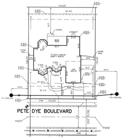
- Topographic surveys which are usually required by architects or engineers for designing buildings, drainage structures, streets and roads, dams, bridges, etc.;
- Right-of-way surveys to determine locations and dimensions for highway and utility easements.
Who can tell me if I need a surveyor?
In many cases, landowners first contact their local planning board or building official where they may be informed of the need for surveying services. Often, these authorities are looking for confirmation that laws and ordinances will permit the landowner to proceed with their development plan. A Professional Land Surveyor can perform the services that are being asked for, such as:
- preparing a proposed subdivision layout;
- mapping a proposed building project to show if it will encroach on easements or building setback lines;
- preparing a legal property description for the purpose of rezoning a portion of a larger tract of land so that the development can proceed;
- measuring the elevation of a proposed building to determine if it lies within an established flood hazard area;
- preparing exhibits showing the vacation of existing easements, sometimes made necessary by the development plan;
- performing a topographic survey showing the "lay of the land" so that proper drainage runoff can be accommodated in the site grading.
Many times, a title attorney or title insurance agent requests the services of a Professional Land Surveyor in order to clear up an ambiguous property description, or to verify the proper location of structures on the property so that the mortgage lender will agree to assume a loan. Improvement Location Exhibits are often requested by these entities.
When do I need a land survey? A land survey is usually needed:
- Before title in land is transferred;
- Before land is subdivided or platted;
- Before land is developed by construction of roads, fences, buildings, etc.;
- and Before a boundary dispute arises.
Advanced Surveying, LLC is committed
to bringing you a consistently high level of service.